Weather across America

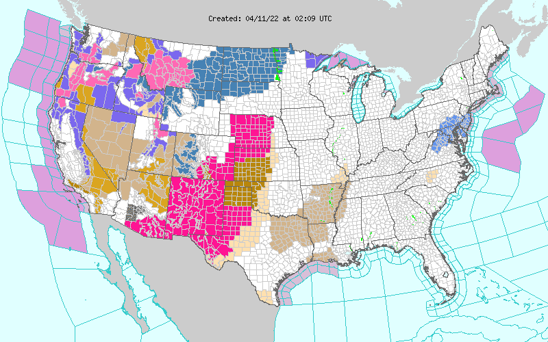
(NATIONAL) There is an elevated to critical threat for fire weather over a large portion of the Southwest and the Central and Southern High Plains, a major late-season winter storm will impact the West with strong winds, heavy rain and heavy mountain snow, and severe weather is expected to impact areas of the Southern Plains and the lower-to-middle Mississippi Valley.
A strong low pressure developing near the Pacific Northwest coast is forecast to track inland and drag a cold front with it. This potent system will usher in strong winds, heavy rain and mountain snows across the Inter-mountain West Sunday night into Monday. Abundant moisture will be directed onshore within the strong onshore flow, which will help increase precipitation intensity and coverage of the rain across the Coastal Ranges of Oregon and northwest California and switching to heavy, wet snow for the Cascades.
The cold air mass pushing in behind this front and the abundant moisture will overspread the Great Basin and the Northern Rockies through Monday. As the system exits the Rockies and enters the High Plains it will deepen further becoming a potent late season winter storm for the Rockies and the Plains. Some of the highest terrain will have accumulations of 1 to 2+ feet, with the higher amounts likely over the Oregon Cascades.
Heavy wet snow is expected to spread from eastern Montana to western North Dakota by Tuesday, where accumulations of a foot or more will be possible. Numerous Winter Storm Watches and Winter Weather Advisories are in effect from Washington, Oregon, California eastward to Minnesota.
The Central and Southern High Plains, and parts of the Southwest, have been and will continue to have low humidity and gusty winds. Critical conditions for the spread of wildfires have been identified by Storm Prediction Center into early next week. A vast area from southern Arizona to Nebraska and south to South Texas have Red Flag Warnings and High Wind Warnings in effect. This threat will continue until the strong storm system in the West ejects out into the Plains midweek.
In contrast, much of the central and eastern states will be relatively calm weather-wise, but there will be a cold front crossing the Midwest and the Great Lakes region late Sunday through Monday. These features will bring a threat of rain and perhaps a little wet snow to areas of the Upper Midwest. Showers and thunderstorms are expected to develop across the Central and Southern Plains ahead of the approaching front. Some of the storms may become severe per SPC, who has a Slight Risk highlighted for Monday.
The coverage and intensity of these storms are expected to impact more of the Lower/Mid Mississippi Valley on Tuesday. These storms will be capable of producing large hail, damaging winds, and a couple of tornadoes.
Comments
This story has no comments yet