Weather across America

(NATIONAL) Excessive rainfall and severe weather throughout the Southeast, showers and thunderstorms expected from the Pacific Northwest & Northern Rockies to the Northern Plains, and record warmth expected in parts of the West & Midwest.
Multiple rounds of showers and thunderstorms engulfing the Southeast U.S. will begin to make their way north into the Mid-Atlantic for the first half of the week. An upper-level low meandering over the Deep South continues to direct copious amounts of Gulf moisture northward while a stationary front also acts as a trigger for thunderstorms each day. WPC maintains an expansive Marginal Risk (threat level 1/4) for excessive rainfall that stretches from the Lower Mississippi River Valley to as far east as the Mid-Atlantic coast through Tuesday.
Sunday, a slight risk (threat level 2/4) includes areas from the central MS/AL border on east tor the Carolina coast. As the storm moves east on Monday, so will the slight risk area which includes areas as far south as South Florida and as far north as central Virginia. Look for the excessive rainfall threat to persist into Tuesday over the Mid-Atlantic, highlighted by a Slight Risk in parts of Virginia and northeast North Carolina.
In terms of severe weather, the Storm Prediction Center (SPC) has highlighted a marginal risk from the central Gulf Coast to the Georgia Coast Sunday. The severe threat on Monday stretches south into the Florida Peninsula and as far north as the southern Appalachians. A troughing pattern over the western U.S. will direct a series of disturbances at the Northern Rockies and High Plains.
SPC has issued a slight risk (threat level 2/5) for Sunay from the Snake River Valley of eastern Idaho through parts of the northern Rockies and High Plains of northern Wyoming and central Montana. Severe thunderstorms within the Slight Risk pose a threat for damaging wind gusts and large hail. The pattern remains unsettled over the Pacific Northwest on Sunday with numerous showers and high elevation mountain snow on Monday.
A passing cold front will introduce a chance for showers as far south as southern California by Monday night. Sandwiched between the wet conditions in the Southeast and Northwest is a mostly dry stretch of weather for the Southwest, Midwest, and Northeast. Extensive cloud cover is contributing to unusually cool temperatures than normal for May in the southeastern U.S. Daily temperatures will be below normal from eastern Texas all the way to the Carolinas.
Lingering northwesterly flow will keep temperatures cooler than normal in New England Sunday before warming up to more seasonal levels on Monday. Early morning frost is also possible Sunday in the northern most portion of Michigan's Mitten. In contrast, ridging over the Rockies and Midwest will favor very warm temperatures for mid-May, making Mother's Day Weekend feel more like an early kick-off to summer in some locations.
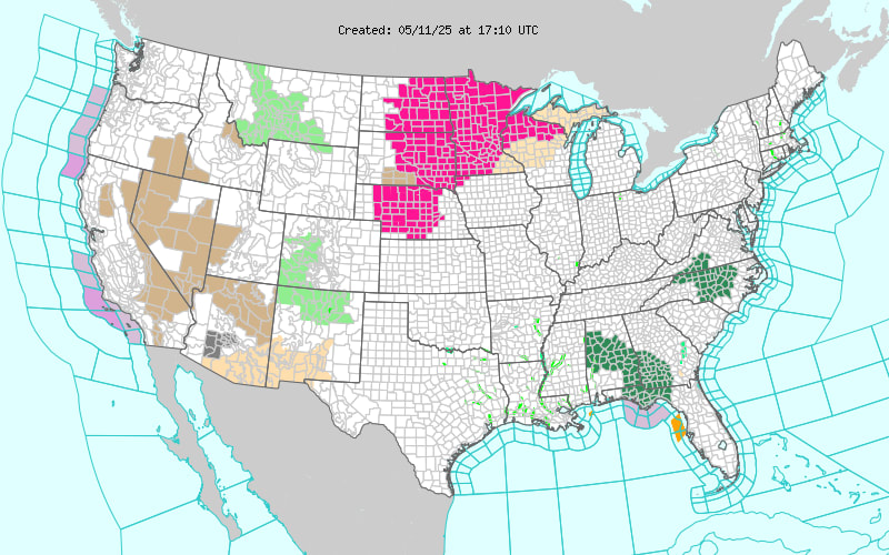
Record warm minimum temperatures are forecast Sunday in southern California, the Great Basin, and in isolated parts of the Northern Rockies. The hottest temperatures versus normal will be found in the Upper Midwest where widespread record warmth for mid-May is expected from the Dakotas to Minnesota through Tuesday. Temperature anomalies in the Midwest are likely to range between 15-25 degrees above normal and will potentially approach 30 degrees above normal in the Dakotas into the first half of the week.
NWS's HeatRisk does depict an expansive area of Moderate heat-related impacts with scattered areas of Major heat impacts in parts of North Dakota and northern Minnesota. Residents who are sensitive to heat, especially those without effective cooling and/or adequate hydration, should plan accordingly for a stretch of stressful heat that will persist through at least the first half of the week.
Comments
This story has no comments yet